 If the political administrative division of 1977 increased the number of Cuban provinces from 6 to 14, the bureaucratic reshuffling of 2011 raised it to 15, because it reduced the size of the capital, cutting the urban environment in two, and distributing the 19 municipalities of Havana between the new Artemisa and Mayabeque provinces.
As in similar readjustments the State’s reasons for uprooting thousands of inhabitants in Havana and Pinar del Rio, we assume that offices, tensions and expectations grow while the regional boundaries are configured. They change the provincial boundaries but not the municipalities.
As we discussed, the configuration of Mayabeque, composed of 11 municipalities of Habana province, with San Jose de Las Lajas as the top; we will refer to Artemisa, a province cut and pasted from three municipalities from Pinar del Rio (Bahía Honda, Candelaria y San Cristóbal), plus the remaining eight of the extinct Habana province: Alquízar, Bauta, Caimito, Guanajay, Güira de Melena, Mariel, San Antonio de los Baños and Artemisa itself, which was in Pinar del Rio province until 1976, along with Guanajay and Mariel.
The new Artemis, the largest municipality in size and population of the old structure, becomes the thirteenth province in the country by size (4004.27 square km), the eleventh in population (502,392 inhabitants) and the third in population density, preceded by the capital and Santiago de Cuba. Bordered on the south by the Gulf of Batabano, on the east by Havana City and Mayabeque, on the west by Pinar del Rio and the north by the Straits of Florida and the Gulf of Mexico.
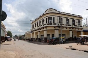
Of its current territory, the oldest are Alquízar (1616) and Guanajay (1650), followed by San Cristobal (1743), Bauta (1750), Mariel (1768), San Antonio de los Baños (1775), Guira de Melena and Bay Honda (1799). Artemis, founded in 1810, flourished with the development of coffee and the regional sugar industry. The region was the scene of struggles against colonialism and the dictatorships of Machado, Batista and the Castro brothers.
From the geographical point of view it is dominated by the southern carcásica plains, the flood plain at the western end, given the presence of several rivers, the Sierra del Rosario and the red soils and natural features (caves, sinkholes, lakes, coasts and three bays). Within Mariel Bay we find the Majana cove at the narrowest point of the island (31 km).
For its forest reserves, bays, rivers, reservoirs and agricultural potential, livestock and manufacturing, the new provincial structure raises expectations of development that depend on investments, initiatives and freedoms essential to modernize industry (cement, thermal power, textile, agricultural), maintain the road and rail networks, and promote the tourist attractions (Soroa Natural Park, Las Terrazas, Hotel Moka).
The territorial culture evokes illustrious names such as the novelist Cirilo Villaverde (1912-1894), composers Maria Teresa Vera (1895-1965) and Luis Marquetti (1901-1992), trumpeter Arturo Sandoval, the tres guitar player Pancho Amat, singers Polo Montanes (1955-2002) and Alex Puente, the historian Manuel Isidro Méndez (1882-192), the geographer Antonio Núñez Jiménez and cartoonist Eduardo Abela (1889-1965). A tenth of the improvisational peasants, political cartoons, and other expressions of art and literature nest in the region, coexisting with the centers for military training, pedagogy, sports and science.
If all territory is an ongoing identity with urban, geographic or economic elements that characterize and differentiate one from the other, it remains to be seen if there is a convergence between the municipalities of La Habana and Pinar del Rio added to Artemisa. The changes the nation needs can dynamite, reduce or strengthen the political-administrative intentions designed by the current military bureaucracy.

![]()
March 1 2011
